
A weblog for anyone interested in cruising the Great Loop and Inland Rivers
|
A weblog for anyone interested in cruising the Great Loop and Inland Rivers
|
|
|
Updated June 17, 2008 Even though this web page is titled "Mississippi River," it actually describes Calypso Poet's round-about return voyage to Little Rock, her technical (until recently) homeport. There's no way to get to Little Rock from most places (Tulsa would be an exception) without going on the Mississippi. This boat spent its early life on the Tennessee River, although her predecessors were all well familiar with the Arkansas River. Rather than go straight there, however, the Poet’s crew took a "little" detour up the Mississippi River (if you consider going 830+ miles north a short cruise). Once we reached the halfway point for our summer cruise days, we turned around and headed south. This travelogue describes our summer 2007 travels on the Upper Mississippi from Cairo, IL to Stillwater, MN and back, and our voyage on the Lower Mississippi from Cairo, past New Madrid, Memphis, Tunica, and Helena, to mile 600, where we turned up the White River, then onto the Arkansas River, to get back to Little Rock, Arkansas. For info on Lower Mississippi mile 600 south to New Orleans, read our Great Loop (2002-2003) and summer 2004 cruise logs. 2008 update: Sadly, the information we've posted below on marina fees and fuel prices is already outdated, only one year after we did the cruise! Please do not rely on the prices reported below. Much more sadly, the Upper Mississippi is badly flooding in the summer of 2008, with terrible consequences to the many towns and marinas we were fortunate to visit last year.
June 20, 2007 / Pebble Isle Marina, New Johnsonville, TN (Tennessee River mile 96) to Kentucky Dam Marina, Gilbertsville, KY (Tennessee River mile 23)
It’s hard to
leave friends and a favorite port when your return is
uncertain, but we bid good-bye to
Pebble Isle Marina
this morning as we started our Mississippi River cruise. Randy and Tammy
run a first-rate It was a few minutes after 8 a.m. when we left the fuel dock, headed back down the Tennessee River. By the time we reached the main channel, the wind had picked up, blowing from the northeast and creating a little chop against the downstream current.
We’ve put
all our music from home into the iPod, and it’s been fun listening
to our songs in alphabetical order. We’ve discovered we have seven
versions of Jimmy Buffett’s “A Pirate Looks at Forty,” and we have fifty
songs whose titles begin with the word It was somewhat cool today, due to the northeast wind, a bit unusual at this time of year. The day’s cruise was uneventful, and we made it to Kentucky Dam Marina by 3 p.m. This is a pleasant place we’ve visited many times in the past, most recently over Memorial Day weekend, when son Jon, daughter-in-law Kat, grand-daughter Sofia, and their dog Stella drove down to visit and enjoy fun in the sun. June 21, 2007 / The Day of Three Rivers (Tennessee--last 23 miles, Ohio--last 47 miles, and Upper Mississippi--first 7 miles) Speaking of fun in the sun, the sun was just coming up when we departed Kentucky Dam Marina at 5:40 a.m. We chose to use Kentucky Lock to access the Ohio River because it’s about 20 miles closer than using Barkley Lock and the Cumberland River. The lake was calm, but as we waited, the wake and rollers from an approaching tow set us to rocking and rolling. Our wait for the lock was fairly short, only one hour. We were joined by a trawler from Sturgeon Bay, Wisconsin, named Recovery.
Passing
Paducah, Kentucky, we entered the
Ohio River in mid-morning. Our wait at Lock 52 was also fairly short,
and we and Recovery were on our way less than 40 minutes after
our arrival. Water levels on the Ohio are dropping, but Lock 53 was letting everyone pass down the river without going through the lock. Work on the new Olmstead Lock and Dam, which will replace Locks 52 and 53, continues. Wonder when will it be operational? Maybe the next time we pass this way.
At points on the Ohio, the navigation channel was so shallow and narrow that upbound tows pulled over to the bank to let downbound tows negotiate the tight space. We overheard one tow captain tell another that he felt he was “cultivating instead of navigating.”
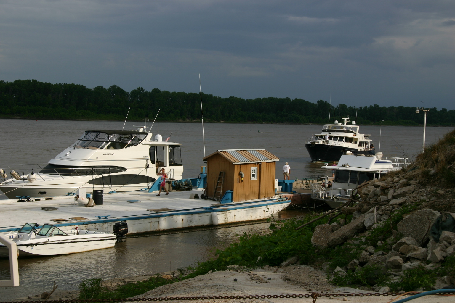
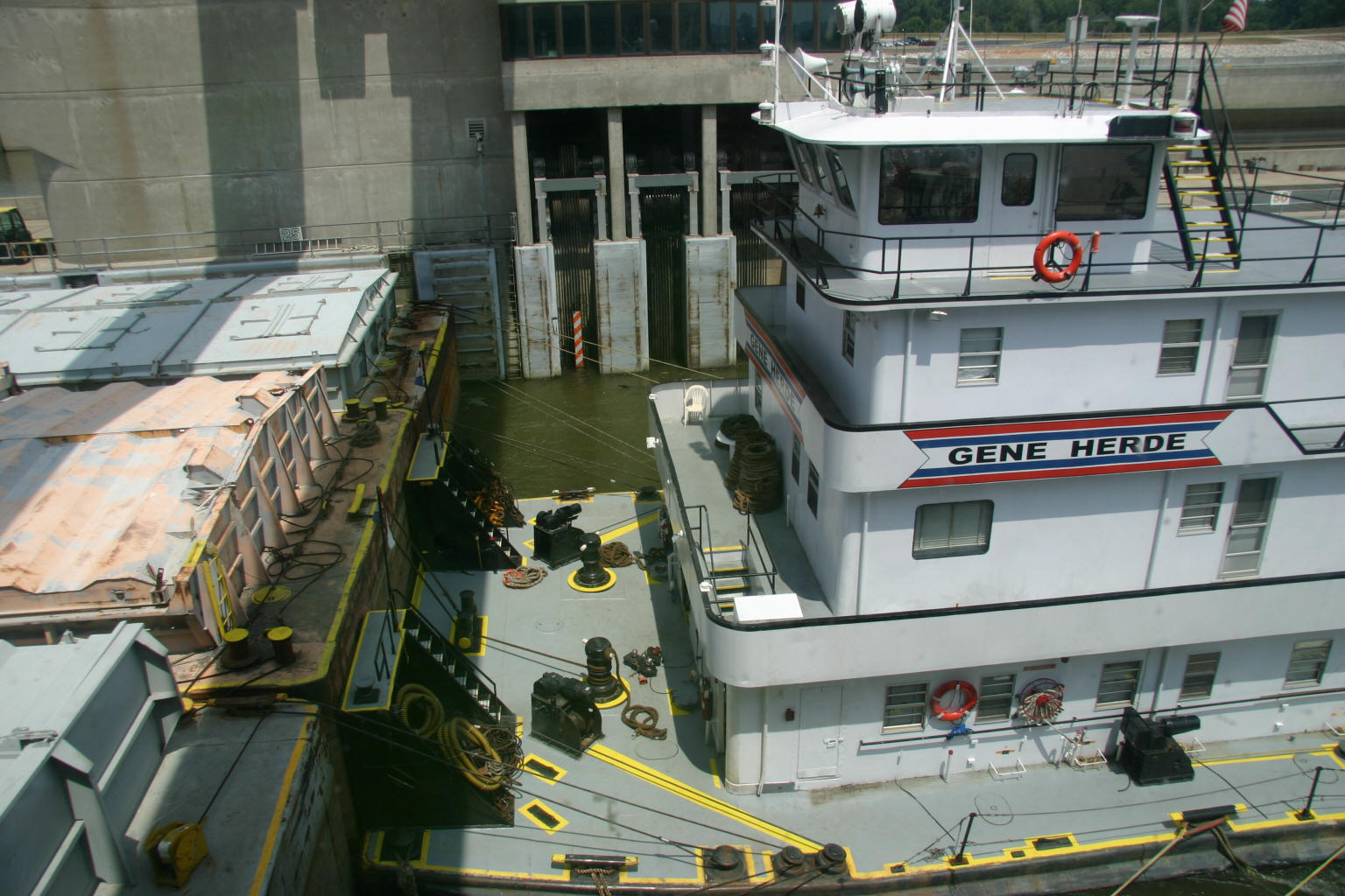
When we turned into the Mississippi River at Cairo, Illinois, the strong current cut our speed in half. After checking the available anchorages upstream and our remaining hours of daylight, we decided to cut the day short and anchor at Boston Bar, just above the I-57 bridge (strong cell phone signal). Gary and Maggie made a shore trip. He thought it was for bathroom duties; she viewed it as a swim break. It was all great fun until she got back to the boat and had to endure having the black river mud washed out of her paws. Today’s run, which included two locks, was just short of 70 miles, but only 7 of those miles were on the Mississippi. June 22, 2007 / Boston Bar Anchorage (Upper Mississippi mile 7.5) to Cottonwood Bar Anchorage (Upper Mississippi mile 78) The water level dropped only a few inches overnight, so we had no trouble leaving the anchorage at 5:40 a.m. The current has eased slightly, and we are making slightly better headway. Recovery hailed us on the radio about 7:45 a.m. They made it up to the Little River Diversion Channel at Cape Girardeau last night, and they were headed for Kidd’s Fuel Dock before proceeding upriver. They plan to get to Hoppie’s (mile 158.5) tonight, so they’re clearly traveling a lot faster than we are. We’ve been looking for potential anchorages on the chart, and as we pass each, we’re making notations as to its suitability. As a general matter, we prefer to anchor on the downstream end of towheads, far enough into the chute to get out of the river current. Consistent with our past experience on the Mississippi, we’ve had to be vigilant about watching the water surface for “drift,” i.e., floating (and sometimes slightly submerged) debris. Gary can usually steer around (or through) it, but sometimes we just have to cut back the throttles, then shift into neutral to slide through. Today the drift seemed worse in the bends and in the reach between Buffalo Island and Bumgard Island (miles 25-29). We thought it was a big piece of drift at first, but the large object floating downstream at mile 31 turned out to be a kayaker. Wonder how far he is going? (Here's a blog Coleen found written by four young men who were canoeing down the entire river (Minnesota to New Orleans) this summer; interesting perspective.) When you're on the Upper Mississippi, hail tows directly on Channel 13. We have two radios on the helm, and today we had one scanning 16 and other channels, one dedicated to 13. We periodically announce our position and direction (e.g., “Northbound pleasure craft at Daniel Light”), and occasionally get a response from a tow not yet in visual range. Downstream vessels have the right-of-way. In bends and other narrowed channel conditions, these large tows need all the room they can get for maneuvering. Talk to the tow captain to arrange your pass or determine whether you should hold back to let him come down. We find 99% of tow captains to be responsive and glad to talk to us. Today’s cruise ended when we anchored behind Cottonwood Bar, having traveled 65 miles in about 12 hours. Gary and Maggie went to shore, where she frolicked on the sandy beach of the island, running, rolling, and swimming. She had a blast. Pretty good for a mature pup of almost 10 years! June 23, 2007 / Cottonwood Bar anchorage (Upper Mississippi mile 78) to Hoppie’s Marine Service, Kimmswick, MO (Upper Mississippi mile 158.5) While you can see every stick floating in the river when you’re cruising upstream at 5.4 miles an hour, the speed does have its drawbacks. There being only a couple of good anchorages above us, we decided to periodically go on plane during the day so that we could reach Hoppie’s Marine Service (a "must stop" for folks doing the Great Loop) in the late afternoon, take on fuel, and relax a bit with easy shore access. As we prepared to leave our anchorage at dawn, we saw a northbound tow motionless about a mile below us, waiting for a southbound tow to pass the bend around the towhead. We called the southbounder, and the captain asked us to wait until he had passed us before we entered the channel. About then, we saw a blue and white trawler coming upstream. We followed this boat, a lovely Marlow named Never Borred, for most of the day, catching up to her the times we throttled up, and then dropping back as we resumed our fuel-efficient speed.
We arrived at
Hoppie’s Marine Service about 4:30. Never Borred was taking on
fuel, so we idled in the river until it was our turn at the fuel pump.
Not long after we tied up, a For those who haven’t been there, Hoppie’s is a unique place. Picture four barges linked together end to end and tethered to the shore, with a few sheds here and there, tables, chairs, and friendly folk to greet you and tie your boat securely against the barges. The most famous aspect of Hoppie’s, however, is Fern Hopkins, who is a fount of knowledge about boating the Mississippi whether you’re headed north or south. When you stop at Hoppie’s, do not fail to get the latest from Fern. Current dockage rate is $1.00/foot (which is higher than reported in Quimby’s 2007 edition) and diesel is selling for $3.06. June 24, 2007 / Hoppie’s Marine Service, Kimmswick, MO (Upper Mississippi mile 158.5) to Grafton Harbor, Grafton, IL (Illinois River 0.0, near Upper Mississippi mile 218) Fern confirmed what the Coast Guard had told us in the last few issues of the Local Notice to Mariners. The main chamber of Mel Price Lock was closed for repairs, and with only the smaller auxiliary lock in operation, it might take several hours to transit the lock. She advised calling the lock operator at Mel Price when we were in the Chain of Rocks canal, let him know when we expected to arrive at his lock, and get our name on the list for locking up. We did as instructed. Tow traffic is steady around St. Louis. One tow was pushing a load of barges filled with grain. A flock of birds accompanied the tow, feasting on the grain that had spilled over when the barges were being filled.
The skies cleared as we entered the lock, and the sun was shining hotly as we left it. Southbound tows were lined up for a couple of miles above the lock. Coleen counted seven waiting for their turn to lock down. We arrived at Grafton Harbor shortly after 4 p.m. This is a shiny new marina, and it seems to be very popular with the local boaters, judging by the number of boats we saw in the area. Dockage is $1.25/foot. We were placed on the “T” of the fourth of five covered docks. Although the marina has wifi, we were also able to connect to an open wireless network at one of the businesses in town. Just below the marina, the Grafton Ferry crosses the confluence of the Illinois and Mississippi Rivers. This private ferry operation began in the fall of 2002, so you may not see it indicated on your charts of the Mississippi or Illinois (it wasn’t on ours). The ferry starts its day at 6 a.m. and stops running at 8 p.m. It appears to have a steady stream of customers crossing each way. Grafton is a tiny town, but it has more than its share of restaurants and antique stores. Don't miss Jimbo's Grocery/Hardware (take the marina courtesy car). We can vouch for both the chicken salad and the potato salad, but have insufficient knowledge to rate the tools and plumbing supplies. We’ll spend a couple of nights here, then head north again on Tuesday. One other thing: A gentleman we met on the dock told us that the Mel Price lock is re-opening on Monday, June 25, and sent us this web link with the story. We were just one day too early! June 26, 2007 / Grafton, Illinois (Illinois River mile 0.0; Upper Mississippi River mile 218) to Two Rivers Marina, Rockport, Illinois (Upper Mississippi River mile 282.3) Leaving at sunrise means a couple more hours of relatively cool cruising before the heat under the black bimini canvas becomes intolerable. We left Grafton at 5:40 a.m. and soon encountered the first southbound tow we’d see today, aptly named Prairie Dawn. The current has lessened a bit. Perhaps the Mississippi is really a gentle river, with the bad currents contributed by the Illinois, Missouri, and Ohio Rivers. We’ll test that theory as we continue north. We reached Lock 25 shortly before 9:00 a.m. Although the locks in this part of the world are listed as having a 15-foot lift, we seem to be lifted between 2 and 5 feet. That short lift cuts down on the transit time. We were in and out of Lock 25 in ten minutes. When we arrived at Lock 24, we saw a northbound tow preparing to leave the chamber and another northbound tow snuggled against the long wall preparing to lock up. When we called the lock operator, however, we were told we could lock up ahead of Capt. Bear Ivie, who had left room for us to squeeze between his forewardmost starboard barge and the lock’s short wall. Many thanks to Lock 24 and to the tow captain for letting us quickly transit the lock and avoid a multi-hour wait for the tow’s double load to lock up. The swing railroad bridge at Louisiana, Missouri has a 16-foot clearance, too low for us to pass beneath, but the bridge opened promptly upon request. It must have been a lucky day for us. When we reached Two Rivers Marina and entered through its buoyed channel, we were stunned to see the depth-finder register 1.8, 1.5, 1.0, 0.8, and 0.6 feet beneath our dangling propellers (we draw four feet) before rising again to about 4 feet at the fuel dock. Didn’t hit anything, that’s lucky. Don’t know whose heart was pounding harder, Coleen’s or Gary’s. The folks at the marina, while cheerful, seemed rather nonchalant about our concern and their entrance channel depth. We took on a couple of hundred gallons of diesel at $3.259/gallon. Dockage was $1.25/foot. The marina has a courtesy van that transient boaters can use. Although Quimby’s rates Two Rivers with its top five-anchor rating, we cannot figure out why. Apart from the shallow-water issue, it has deteriorating open-styrofoam docks. The dock designated for after-hours transients, “C” dock, is rickety and has orange netting, perhaps to indicate that it’s closed, at the shore entrance. We’re not saying this is a bad place, just that it does not rate five—or four—anchors compared to other four- and five-anchor marinas we’ve used in the past. Note: On our return trip downstream, conditions at the marina looked more promising. June 27, 2007 / Rockport, Illinois (Upper Mississippi River mile 282.3) to Quincy Boat Club, Quincy, Illinois (Upper Mississippi River mile 327.7) The extra weight of the diesel fuel we took on must have deepened our draft a bit, as the depth-finder went down to 0.4 feet (!) a couple of times as we went out through Two River’s channel. Fortunately, we made it out without bumping. Coleen called ahead to a marina we were considering using at our next stop, and she asked about the water depth at the entrance. “Four or five feet” was the answer, along with a cautionary, “So be careful.” We decided to look elsewhere, and we found the Quincy Boat Club, who welcomes transient boaters at its dock with 7-8 feet depth. Whew! For 50 cents/foot, the Boat Club also provides water and 30-amp electricity and gracious hospitality (but that part is provided free of charge). In places where the depth in harbors is 12 or more feet, the presence or absence of an extra foot or two is no big deal. When a marina’s advertised depth is four feet, however, dropping an extra foot or two is a very big deal. We hope this is a phenomenon that we do not continue to encounter on this trip, but fear it will endure. We passed Hannibal, Missouri this morning, boyhood home of Samuel Clemens/Mark Twain. Hannibal celebrates its famous son and his most famous characters, Tom Sawyer and Huckleberry Finn. Although they are in two of Twain's great books, we prefer to keep a copy of Life on the Mississippi (originally published in 1883) on the Poet. In it, Twain describes returning to his hometown: The only notion of the town that remained in my mind was the memory of it as I had known it when I first quitted it twenty-nine years ago. That picture of it was still as clear and vivid to me as a photograph. I stepped shore with the feeling of one who returned out of a dead-and-gone generation. I had a sort of realizing sense of what the Bastille prisoners must have felt when they used to come out and look upon Paris after years of captivity, and note how curiously the familiar and the strange were mixed together before them. I saw the new houses—saw them plainly enough—but they did not affect the older pictures in my mind, for through their solid bricks and mortar I saw the vanished houses, which had formerly stood there, with perfect distinctness. It was Sunday morning, and everybody was abed yet. So I passed through the vacant streets, still seeing the town as it was, and not as it is, and recognizing and metaphorically shaking hands with a hundred familiar objects that no longer exist; and finally climbed Holliday’s Hill to get a comprehensive view. The whole town lay spread out below me then, and I could mark and fix every locality, every detail. Naturally, I was a good deal moved. I said, “Many of the people I once knew in this tranquil refuge of my childhood are now in heaven; some, I trust, are in the other place.” The things about me and before me made me feel like a boy again—convinced me that I was a boy again, and that I had simply been dreaming an unusually long dream; but my reflections spoiled all that; for they forced me to say, “I see fifty old houses down yonder, into each of which I could enter and find either a man or a woman who was a baby or unborn when I noticed those houses last, or a grandmother who was a plump young bride at that time.” From this vantage-ground the extensive view up and down the river, and wide over the wooded expanses of Illinois, is very beautiful—one of the most beautiful on the Mississippi, I think; which is a hazardous remark to make, for the eight hundred miles of river between St. Louis and St. Paul afford an unbroken succession of lovely pictures. It maybe that my affection for the one in question biases my judgment in its favor; I cannot say as to that. No matter, it was satisfyingly beautiful to me, and it had this advantage over all the other friends whom I was about to greet again: it had suffered no change; it was as young and fresh and comely and gracious as ever it had been . . . . We look forward to seeing the same succession of lovely pictures he viewed and sharing them with you. June 28, 2007 / Quincy, Illinois (Upper Mississippi River mile 327.7) to Keokuk, Iowa (Upper Mississippi River mile 366) Except for Coleen falling off the boat and into the river, it was a pretty good day. Fortunately, the boat was docked when she lost her footing on the steps down to the swim platform, and Gary helped fish her out of the water pretty quickly. A few bumps, a bruise to the ego (good chance some members of the Keokuk Yacht Club saw her bouncing down the steps), but nothing serious. The day began with a late (for us) start out of Quincy, at 8:40 a.m. At Lock 20, the lock operator let us cut ahead of a northbound tow, and we floated the lock (no lines tying us to the lock wall), making the transit in less than 30 minutes. The Keokuk Railroad lift bridge opened on our approach, and Lock 19 was open and waiting when we arrived. We arrived at Keokuk Yacht Club at 2:05 p.m., did a couple of loads of laundry, and relaxed. Dockage was $1.00/foot, including electricity (no water on the outside wall, where we were tied up). Gary was able to access the local wifi for his computer, although Coleen’s computer didn’t pick it up. Late in the afternoon another 46-foot Carver, Jessica Marie, homeport Sabula, Iowa, came in and docked in the inner harbor. Nice-looking boat! (Okay, we are a little biased.) June 29, 2007 / Keokuk, Iowa (Upper Mississippi River mile 366) to Fairport, Iowa (Upper Mississippi River mile 463.5)
After we left Lock 18, Jessica Marie throttled up and left us again, and we thought we had seen the last of her. Three hours later, however, there she was below Lock 17. She must have arrived about the time a northbound tow was entering the lock and had to wait for two tows to clear the lock. We arrived at Lock 16 about 4:15 p.m. and were relieved to see that our colleague had been able to lock upstream ahead of us this time. We spent the night at Fairport Landing Marina, taking on 200 gallons of diesel for $2.92/gallon and paying $25.00 for overnight dockage. The marina harbor is too small to accommodate anything but runabouts. While they do permit overnight ties at the fuel dock, you may be able to stay in one of the large slips, which are perpendicular to the current. We went into a slip whose tenant was gone for the weekend. Fairport Landing is not a fancy place, but it does have a very popular (and casual) restaurant, “The Lighthouse” (which must have formerly been called “The Charthouse,” as some signs for the latter name are still around). We tried the #1 best-selling sandwich, the “Unbreaded Tenderloin,” which is a huge hunk of meat on a regular-sized bun. Great with a pitcher of cold Bud Light. June 30, 2007 / Fairport, Iowa (Upper Mississippi mile 463.5) to Bettendorf, Iowa (Upper Mississippi River mile 486.2) Today was going to be a short day, so we tried to sleep in (making it to 6:00 a.m.). As we were drinking our coffee, we saw Loree Eckstein, a northbound tow pass the marina. Rather than rush our departure rituals to push ahead of the tow, we decided to let it go and head out around 9:00 a.m. Stepping out on the bridge, we saw that the mayflies had blossomed overnight, carpeting the starboard (lee) side of the boat. While we don’t necessarily mind having insect hitchhikers, mayflies molt and leave their discarded exoskeletons on the surfaces they cling to. We spent an hour with the broom, shooing mayflies. Arriving below Lock 15 at 11:30 a.m., we were surprised to see Loree Eckstein waiting to lock up, but she had apparently been held up by north- and southbound tows ahead of her. The lockmaster told us he was locking a rec boat down and that we could enter the lock when it exited, letting us cut ahead of Loree E. When the horn sounded for the southbound rec boat to exit, nothing happened. We waited, waited, waited, and finally saw the boat. It was a houseboat, sideways in the lock and not making way. The lockmaster got on the radio and announced that the southbound rec boat was stalled and asking if any northbound boats could assist in towing her. Gary figured he was talking to us, the only other boats around being Loree E. and a small runabout. We agreed to tow the houseboat back into the lock and take it up with us, and we did. So now I guess you can refer to us as “tow captains.” We stayed at the Isle of Capri Marina (associated with the casino). Dockage was a flat $20.00 (only $10.00 on weekdays). Although we didn’t buy here (yet), we noted that diesel was selling for $3.15. The current at the Isle of Capri harbor entrance is very strong, and the entrance is narrow. It’s best to enter from downstream at a 45-degree angle. July 1, 2007 / Bettendorf, Iowa (Upper Mississippi River mile 486.2) to Sabula, Iowa (Upper Mississippi River mile 535.5)
On the
weekends, Auxiliary Lock 14A is open to recreational boaters, beginning
at 8 a.m. We arrived a few minutes before the scheduled opening, but the
lock operator was on duty and put us through quickly and easily.
As we passed the town of LeClaire, we saw a pretty riverboat, the Twilight, leaving the dock, her calliope whistling, “Waiting for the Robert E. Lee.” This boat carries up to 149 passengers. With big diesel-electric engines, she blew past us on her way up to Dubuque. We were lucky to find many of the low railroad bridges already open, and we waited only when trains were coming. We waited for two trains at the Clinton Railroad bridge (call on Channel 13, even though the navigation chart says to use 14/16) and waited for another at the Sabula Railroad bridge.
July 2, 2007 / Sabula, Iowa (Upper Mississippi River mile 535.5) to Dubuque, Iowa (Upper Mississippi River mile 580.7)
We have been
remiss in failing to post Maggie’s “squirrel” ratings
As Gary and Maggie were on their morning pre-departure walk, she went into her hunting posture—body frozen, one forepaw up and pointing, intent stare at the target. Then she pounced . . . on a concrete rabbit poised on a sidewalk. Clearly, they make quite lifelike concrete rabbits in Iowa.
Today’s cruise
to Dubuque was uneventful and scenic. Lots of greenery, bluffs lining
the river, houseboats and tents on sandy shores (getting a head start on
the 4th of July holiday). We tied up at the docks of
American Marine at
Dubuque Yacht
Basin,
and we’ll stay here for a week. Dockage is $1.25/foot, and the marina
has a great restaurant,
Catfish Charlie’s, on site, plus associated RV campground, pool,
laundry, and nice pedestrian/bike paths to walk. Maggie gives it three
We were pleased to meet in person Dick and Pat Friedman, along with their charming grandsons, Caleb and Noah. The Friedmans completed the Loop in 2005, and like us, own a Carver 466, named Another One. They brought us a dozen ears of fresh-picked Iowa sweet corn—a great treat! Dubuque’s holiday celebrations include fireworks and an airshow on the 3rd of July. We hope to get some rain while we’re here (to raise the water levels a few inches and to cool things off). July 9, 2007 / Dubuque, Iowa (Upper Mississippi River mile 580.7) to McGregor, Iowa (Upper Mississippi River mile 633.5) We spent a week in Dubuque, both because we wanted to be safely docked somewhere during the Fourth of July holiday period (which seemed to encompass the weekends on either side) and because it was a good place for Jon and Stella to visit with us (i.e., not too long a drive). While in Dubuque, we enjoyed visiting the National Mississippi River Museum & Aquarium. In addition to all the exhibits on the history of the river, steamboating, and the wildlife, it featured five aquariums (one of which held enormous catfish; others held unusual varieties of catfish and other fish), river otters, and birds. Coleen enjoyed playing towboat captain in a simulator, successfully taking her tow out of a lock without taking out other boats, bridges, or the lock walls. Visitors can also tour a restored Corps of Engineers dredge, the William M. Black, built in 1934 to keep the Missouri River navigable. Not only is the dredge open to visitors during the day, but it is also a “boat and breakfast” for those who would like to spend the night . . . maybe when the weather’s cool, but not now, with temperatures in the upper 90s (although you would get an authentic experience of living conditions when this was a working boat).
Galena exuded 19th-century charm, featuring a trolley for tours, lots of interesting shops and restaurants, and many restored old homes and commercial buildings. We did not visit the wineries, but have sampled Galena wine in the past and found it quite tasty. We left Dubuque on Monday, July 9, at 6:10 a.m. At Lock 11, the captain of the tow J.B. Kleinpeter let us lock ahead of him. This boat belongs to Ingram Barge Company, whose captains are the most pleasant of all we’ve encountered on the rivers. We were glad not to encounter any tows while negotiating the twisty channel curves between Cassville, Wisconsin ("Come Join the fun at Twin-O-Rama July 20, 21, and 22!"), and Guttenberg, Iowa. We recognized three tows we’ve seen before, Cooperative Venture, Lexington, and Samuel B. Richmond, now southbound.
Lock 10 was a
pleasure, in and out with no waiting. We docked on the “T” of the first
pier at McGregor Marina in
McGregor, Iowa, paying a dockage rate of
$35.00. We must compliment the young man who was the best dockhand we’ve
encountered so far on this cruise. The marina sits at the foot of main
street in the
town of McGregor (founded in 1837), and we enjoyed looking in the
storefronts as we strolled with Maggie. A limestone bluff behind the
north side of the street was notable for its many caves, used in earlier
days for storing ice and other things needing a cool environment. We
learned that the
Ringling
Brothers (of circus fame) got their start in the entertainment
business in McGregor. Maggie awards two
July 10, 2007 / McGregor, Iowa (Upper Mississippi River mile 633.5) to LaCrosse, Wisconsin (Upper Mississippi River mile 697.3) On our fourteenth cruising day since leaving New Johnsonville, Tennessee, we were enthralled with the sight of bald eagles soaring overhead, perched on rock jetties watching “eagle-eyed” for fish, and standing vigil in the top branches of dead trees, surveying their domain. We saw too many eagles to count, giving us personal confirmation that the decision to remove these birds from the Endangered Species List was probably correct. We were waked pretty hard during the night, but didn’t get up to see what boat did it. But now we think we know. As we entered Lock 9, we were told to watch out for some loose boards that had fallen off the paddlewheel of the northbound Delta Queen riverboat, which the lock operator said had passed through during the night. We saw the red painted paddlewheel timber floating ahead of us in the lock and nudged one piece aside. Gary thought he might be able to pick it up, but it was too heavy to lift out of the water. Too bad, would have made a nifty souvenir! Winds picked up throughout the day, so we were glad to arrive at Pettibone Boat Club in LaCrosse and to dock there without incident. Dockage was $1.00/foot. Late in the afternoon, we watched a group of musicians setting up to play in the patio area. While Tuesday night seemed an unusual night for live entertainment, word was evidently out in LaCrosse, as a large crowd enjoyed the band until well after sunset.
Maggie is not
sure she remembers what a squirrel looks like any more, having seen only
one in the last few weeks. Here at LaCrosse, however, she did spot a
couple of groundhogs, which raised her spirits (and her pointing
forepaw). She’ll give Pettibone’s a fat bank-burrowing rodent rating of
two: July 11, 2007 / LaCrosse, Wisconsin (Upper Mississippi River mile 697.3) to Wabasha, Minnesota (Upper Mississippi River mile 759.3) After yesterday’s gusty wind, Coleen was a little apprehensive about leaving the dock this morning, but at 5:40 a.m., there was only a small breeze. Once the sun was fully up, the wind increased. Still, as all of today’s locks were oriented toward the north and northwest, the same direction the wind was coming from, we had no trouble in transiting the five of them. Again today, we encountered tows we met earlier in this cruise: Captain Bear Ivie and Gene Neal, now southbound. There were scads of houseboats on each pool, mostly rental boats. We hoped the wind was not giving them too much trouble. We were recognized and hailed by a southbound cruiser, Benanna Boat, out of Davenport, Iowa. The skipper knew us because he was familiar with this website, and we chatted for several minutes on Channel 68. We were glad to hear that this site’s been a useful tool for others planning Great Loop and other extended cruising, and we invite any readers to give us a shout on the VHF radio if they see Calypso Poet passing by.
Today’s
destination was
Wabasha, Minnesota—home of eagles and
grumpy old men
(specifically, those in the movies, but we suspect there are plenty of
non-acting GOMs in the area as well). We docked at the
Wabasha
Marina/Boatyard at 1:48 p.m., just across the river from a dredging
operation being set up by the Corps of Engineers.
We can recommend dinner at the Anderson House hotel/restaurant, not only because of the delicious food and historic ambiance (the oldest operating hotel in Minnesota), but also because they’ll pick you up at the marina.
Maggie scared
up a little rabbit on her afternoon walk with Gary, but saw no other
wildlife than a robin or two. Boat on/off access was easy enough, but
dogs and owners must walk past a lot of tempting, manicured lawn before
they get to the permissible grassy rest area on the backside of the
harbor. For that reason, she’s limiting Wabasha’s squirrel rating to
two: July 12, 2007 / Wabasha, Minnesota (Upper Mississippi River mile 760) to Red Wing, Minnesota (Upper Mississippi River mile 791) Today’s short cruise took us from Wabasha to Red Wing, crossing 22-mile-long Lake Pepin. It would have been an exhilarating day for sailors, with the northwest wind gusting to 24 mph from time to time. As our course was northwest all day, we were glad not to have to dodge sailboats or to have those gusts and waves hitting us on the beam.
We stopped at
Red Wing Marina, in a small basin on the right descending bank. Sharing
the basin with the marina is the Red Wing Yacht Club, whose floating
metal boathouses are tightly clustered. Dockage was $56.00. Dogs are
restricted to using a sandy patch behind the dumpsters, unless owners
want to walk them north toward the city park. No squirrels in sight.
Maggie saw no reason to award more than two squirrels
Walking into town past the grain elevators just south of the marina, Coleen noted all the spilled corn kernels lying in the street. There are either no rodents around here, or they do a particularly effective job of dispatching them. The town of Red Wing is very pretty in summer, as every building in the downtown area had colorful window boxes or baskets of petunias. It was a short walk to the post office and a large grocery store. And if you need work boots, well, you can probably find them in your size. July 13, 2007 / Red Wing, Minnesota (Upper Mississippi River mile 791) to Stillwater, Minnesota (St. Croix River mile 23.3) and Bayport, Minnesota (St. Croix River mile 19) Good thing we are not too superstitious, it being Friday the 13th and all (although we give the Boating Gods their due). Coleen felt a twinge of nerves when the iPod played “Calypso Breakdown” and “Can’t Find My Way Home” (we haven’t gotten too far in the alphabet). But it was a sunny, calm day, and we breezed in and out of our northernmost lock, Lock 3 on the Mississippi, squeezed under the Prescott Railroad bridge with at least six inches to spare, and entered the St. Croix River. Several boats had gotten an early start on the weekend. The shores of the Kinnickinnic narrows and the Catfish Bar were lined with cruisers and houseboats, bows wedged on the shore, sterns floating, ladders extending from the bows down to the sandy beaches. A good part of the St. Croix is no-wake zoned, and it must be enforced well. We didn't see anyone violating the marked areas.
Bayport Marina’s transient slips are just north of the gas dock. Pretty nice place, although the on-site restaurant, Clyde’s, has gone out of business. With a BoatU.S. 25% discount on dockage, we’re paying $112.00 for three nights. Not everything here is a bargain; it’s a good thing we don’t need fuel right now. They’re selling diesel for $3.959, gas for $4.449. Ouch.
Maggie enjoyed
walking the grounds of the marina. She saw plenty of rabbits and her
first beaver. The beaver was swimming alongside the dock, keeping one
eye on us and the dog. When Maggie lunged toward it, the beaver flipped
its tail, splashed her, and dove. She gave us a “What was that?” look.
Maggie gives Bayport three slightly damp
July 16, 2007 / Bayport, Minnesota (St. Croix River mile 19) to Wabasha, Minnesota (Upper Mississippi River mile 760) We had a good weekend for family history. Back in 1951, Coleen’s parents were living in Lakeland, Minnesota, as her father was working for a construction company building a bridge across the St. Croix River at Hudson, Wisconsin. The bridge is now known as the eastbound span of the Interstate 94 bridge (even though there were no interstate highways in 1951). Her mom worked at a hospital in New Richmond, Wisconsin, and that’s where Coleen was born. We drove up there. No commemorative signs or anything, but they do have a new Super Wal-Mart. Then we drove to Isanti, Minnesota, where Coleen’s great-great-grandparents, Peter and Brita Dahlberg, settled when they immigrated from Sweden in 1903. We found their graves in the Isanti Union Cemetery. On Sunday morning, we drove to Minneapolis, admired the network of skywalks connecting the buildings downtown, and stopped to view the last two locks on the Mississippi River, at the St. Anthony falls. Time to head south again! We got an early start Monday morning, leaving Bayport a little before 6 a.m. in a light foggy drizzle. Later the sun came out, and the wind came up from the southeast. Lake Pepin was still choppy, but that’s probably its normal state. The day’s cruise was uneventful. We stopped early to avoid afternoon thunderstorms, going back to friendly Wabasha Marina, where we stayed on the way north. July 17, 2007 / Wabasha, Minnesota (Upper Mississippi River mile 760) to LaCrosse, Wisconsin (Upper Mississippi River mile 697.3) The weather is unsettled to the south of us. Strong thunderstorms are predicted for the afternoon and evening. We decided to go no further than LaCrosse, although that meant an early afternoon halt to the cruise. We transited five locks today, all without delay. We saw several tows, mostly northbound with empty barges, destined to be filled with grain. At Lock 6 (Trempealeau), Gary had a friendly radio chat with Joe Glinski, who keeps Our Villa, a Lord Nelson Victory Tug at the marina there, and who plans to start the Great Loop in the late summer. We stopped again at Pettibone’s Boat Club in LaCrosse. Didn’t realize it when we were here a week ago, but the restaurant has a two-for-one burger special on Tuesdays, so we chowed down and enjoyed the live music. Bad weather is forecast, so we may be forced to slow down to stay out of the way. July 18, 2007 / LaCrosse, Wisconsin (Upper Mississippi River mile 697.3) to Marquette, Iowa (Upper Mississippi River mile 634.6) We didn’t get the predicted storm at LaCrosse, as the weather system moved to the south. As we headed south today, however, we thought it prudent to stop a little early and stay out of the way of severe storms. This turned out to be a lucky decision, as hanging back a bit kept us away from two weather-related incidents on two successive days. But first, let's talk about the day's cruise. We stopped in Lansing, Iowa, to fill the fuel tanks at Lansing Marina. Diesel was selling for $3.06/gallon, but they knock off 5% if you pay with cash or check, and the fuel dock is very easy to access. Good place to stop. Lock 8 was a quick in-and-out, but Lock 9 held us up for 2 ½ hours. Not only did we wait for the northbound double tow, but we were subsequently trumped by the Corps of Engineers tug General Warren, who came down the river behind us and jumped ahead of us in line for locking down. As they say, rank has its privileges. First incident we avoided: We had planned to stop again at McGregor Marina, but they didn’t answer the phone. We heard from a lock operator that last night’s storms caused major mudslides in the town and that there had been flash flooding in Prairie du Chien, across the river. As we approached McGregor, it was clear that river conditions had changed from our last stop. The river was a café au lait color, with lots of floating logs and branches. We could see heavy equipment working on the road between Marquette and McGregor, scooping the mud to get the road open again. No wonder we hadn't gotten an answer on the phone when we called. Fortunately, the Isle of Capri marina at Marquette, Iowa, just a mile upriver from McGregor, had plenty of dock space, charging us $40.00 for staying overnight. With heavy rain starting in the late afternoon and more storms forecast for overnight, we skipped the casino, cooked dinner on the boat, and settled in for the evening. July 19, 2007 / Marquette, Iowa (Upper Mississippi River mile 634.6) to Sabula, Iowa (Upper Mississippi River mile 535.5)
We spent a long
day running down the coast of Iowa. Our luck with locks is running out.
Lock 10 opened promptly; Lock 11 made us wait 15 minutes; and
Lock 12
held us up for 2 ½ hours. Because we made good time early in the day (the first two locks and a nice increase in speed thanks to the current), we decided to skip Dubuque and go down to Sabula. Glad we were not here on the 18th, as we might have stayed at Home Port again. During the storms that night, a tow trying to position its barges to transit the railroad bridge backed into the dock at Home Port, tearing it up pretty good and sinking two boats in the process. (Note: We later learned the tow was the Loree Eckstein, one that we've seen repeatedly on this trip.) The town of Sabula’s courtesy dock was not touched, and we gratefully tied up there for the night. July 20, 2007 / Sabula, Iowa (Upper Mississippi River mile 535.5) to Davenport, Iowa (Upper Mississippi River mile 484) We encountered eleven tows today, nine of which were headed north. This made for bottlenecks at the locks. It took about an hour and a half to get through Lock 13 (could have been worse). We were fortunate to have some northbound runabouts who wanted to go up Lock 14, so the lockmaster arranged to lock all the pleasurecraft up and down between sessions for the double tows who were headed down. The auxiliary lock at 14 is used for pleasurecraft, but it's only open on weekends (beginning at 4 p.m. on Fridays).
The marina is situated very close to the historic village of East Davenport, and the riverwalk trails that flank the marina are filled with cyclists, walkers, and people just out enjoying the sunshine. The local public transportation company operates a water taxi, Channel Cat, and it has a stop just to the north of the marina. For $5.00, you can buy an all-day ticket, getting off and on at Moline Landing, Beacon Harbor, Bettendorf Landing, or the John Deere Commons Landing.
Jon and Stella
came over for the weekend (a fairly short drive from Naperville), and we
again enjoyed their company. We visited the fascinating (truly!)
John Deere Pavilion, with its displays of antique and modern farm
equipment manufactured by the company. We also drove over to LeClaire, Iowa, with the express purpose of visiting the Buffalo Bill museum. William “Buffalo Bill” Cody was born in LeClaire in 1846, and this little museum has miscellaneous tidbits associated with him and his legendary “Wild West Show,” although Cody moved out of the area when he was still a young boy. If you like quirky 1950s-style exhibits (it will take you back in time for sure), then you should make a visit. There’s a courtesy dock in LeClaire right above the museum, for those who would visit by water. Associated with the museum is the dry-docked (and sadly deteriorating) Lone Star, a 19th-century riverboat, probably originally built as a wood-burning boat that brought down log rafts, later converted to coal (Thanks, Larry!). The museum is trying to raise funds for its restoration.
Maggie really
enjoyed hunting the rabbits that abound outside the marina (and watching
the ducks, geese, and muskrats in the water around the lilypads). Great
place to walk the dogs. Stella was less comfortable going up and down
the wooden stairs that led to the transient dock. They’ve conferred and
advise me that a three-squirrel
July 23, 2007 / Davenport, Iowa (Upper Mississippi River mile 484) to Fairport Landing, Iowa (Upper Mississippi River mile 463.5) Short day, easy cruise, few tows, only one lock—which was open and waiting for us as we approached. If only the temperature had been 75 degrees, the day would have been perfect. But we are not complaining, no siree, in case the Boating Gods are listening. We’re going to alternate some short days, long days in the coming week. We stopped at Fairport Landing at 11:15 a.m., refueled (diesel selling for $2.90 today), walked Maggie, relaxed, and for dinner, re-enjoyed the unbreaded tenderloin sandwich and pitcher of beer at the Lighthouse Restaurant. July 24, 2007 / Fairport Landing, Iowa (Upper Mississippi River mile 463.5) to Keokuk, Iowa (Upper Mississippi River mile 366.1) Our trip log shows that we’ve covered 1,384 miles since leaving New Johnsonville, Tennessee, on June 20, and we have a lot of miles to go. Although it was short, today’s cruise was complicated by a greater number of tows, three locks, and two railroad bridges that were too low for us to get under on our own. Lock 16 was quick; we had a short wait for a north-bound tow to exit Lock 17 before we could lock down; and we waited an hour and 45 minutes to get through Lock 18. The northbound tows are pushing loads of empty barges, which float high on the water like marshmallows on a cup of cocoa. It was a long day. We arrived at Keokuk Yacht Club at 5 p.m., did some laundry, cooked some dinner, and turned in early. July 25, 2007 / Keokuk, Iowa (Upper Mississippi River mile 366.1) to Hannibal, Missouri (Upper Mississippi River mile 309) I guess we were docked too close to the “streetlight” that illuminates the area between the yacht club and the seawall. A variety of little bugs found every tiny opening in the canvas enclosure and made themselves at home on the flying bridge, the seat cushions, the ceiling of the aft deck, and countless other places. Once again we are glad to have the gallon-sized WetVac, which holds about a gazillion bugs.
We felt as
though we were river pilgrims in our visit to the
Mark Twain Boyhood Home and Museum, imagining Hannibal as it was in
the 1840s-1850 and soaking up July 26, 2007 / Hannibal, Missouri (Upper Mississippi River mile 309) to Grafton, Illinois (Illinois River 0; Upper Mississippi River mile 218) Another long day, three locks, more than ten hours on the water. Maybe the length of the cruise was why we saw so many tows, thirteen in all. After we passed Bob Stith (a tow we’ve seen several times on this trip), the captain radioed us to chat. Turns out he lives in Searcy, Arkansas, when he’s not working on the river. On our northbound voyage, we expressed our unhappiness with the shallowness of the harbor entrance at Two Rivers Marina. We think it only fair to tell you that as we passed today, we noticed a dredge working in their entrance channel. That’s good. It was also good to stop again at Grafton Harbor, even though we’ll only stay one night this time. July 27, 2007 / Grafton, Illinois (Illinois River 0; Upper Mississippi River mile 218) to Alton, Illinois (Upper Mississippi River mile 202)
Alton’s a fun
town, holding
monthly block parties downtown (sponsored by the local bars). We
were there for this month’s Jimmy Buffett-themed event. Speaking of the
Great Loop, imagine our surprise to be recognized and greeted by Julie
(there on her 380 Carver Santego Sugar Shack), whom we met on
Hilton Head Island in the spring of 2003.
Other highlights of Alton included visiting the National Great Rivers Museum, touring the Mel Price lock, and chowing down at Fast Eddie’s Bon-Air. This restaurant/bar is famous for its cheap (but tasty) food and for the vast quantities of beer it sells. Hamburgers are 99 cents; shrimp 29 cents each; pork kebabs for $1.29; bottled beer for $2.50. I think I know where they make their profit. While the Poet stayed in Alton, Coleen flew to Minneapolis for a meeting, and Gary drove Maggie to Little Rock, where she’ll stay with Grandma while we do the last, non-dog-friendly stage of the cruise. August 3, 2007 / Alton, Illinois (Upper Mississippi River mile 202) to Kimmswick, Missouri (Upper Mississippi River mile 158) A great thing about an out-and-back cruise is that on the way back, you’re familiar—sort of—with the water you previously came up. Neither the river nor your experience will be exactly the same, however. Mark Twain described his revelation as a cub pilot heading downriver after having made the trip upstream from New Orleans to St. Louis: When I returned to the pilothouse St. Louis was gone, and I was lost. Here was a piece of river which was all down in my book, but I could make neither head nor tail of it; you understand, it was turned around. I had seen it when coming up-stream, but I had never faced about to see how it looked when it was behind me. My heart broke again, for it was plain that I had got to learn this troublesome river both ways. As we pass under all the St. Louis and other Mississippi River bridges on our way home, we will not be able to forget the horrifying news coverage of the I-35W bridge collapse in Minneapolis on August 1. Our hearts are sad for those who died and were hurt, and we offer our sympathies and thoughts to all those affected by the tragedy. We got to Hoppie’s around noon, having had good luck with both the Mel Price lock and Lock 27. In talking to Fern, we learned that the town of Kimmswick now has only one restaurant, the Blue Owl, and that it is only open for limited hours (10 a.m. to 3 p.m. on Tuesday-Friday, 10 a.m. to 5 p.m. on the weekend). So our advice to you is to arrive at Hoppie’s early enough (or leave late enough the next day) to enjoy the yummy food and bakery items. In the morning, we plan to head on down the river. We hope to anchor around Brown’s Bar (Upper Mississippi River mile 22) tomorrow night; at Caruthersville, MO on Sunday night; and to be in Memphis on Monday night. August 4, 2007 / Kimmswick, MO (Upper Mississippi River mile 158) to Boston Bar anchorage (Upper Mississippi River mile 9.5) The remarkable thing about today's cruise was seeing how much the river has dropped since we came upstream six weeks ago. Dredges are working here and there to restore depth to the river channel. At Cape Girardeau, a tow ran aground on a shoal, and its barges broke loose. The morning Coast Guard broadcast warned us to "transit the area with extreme caution." Will do. The barges had been rounded up by the time we got there, but the tow was not completely reassembled. Places we have noted as potential anchorages in our chart look very different now, and most are too shallow to enter. We were not comfortable with the looks of Brown's Bar, so we chose not to go in there, and we knew that it would be foolhardy to enter the lower end of the towhead at Boston Bar, where we stayed on our northbound leg. (At Hoppie's we had received confirmation of news that Angelo Towhead was presently dry--or if not, too shallow to enter--so we didn't even try to go there.) Instead, we found a straight stretch of river alongside the Boston Bar towhead, and we anchored behind the wing dam and to the east of a nun buoy in about 10 feet of water. We could see the I-57 bridge below us. The channel was on the other bank, and tows had plenty of room there to pass each other without threatening us. It wouldn't have been a good place to anchor with Maggie (who insists upon going to shore), but as she's in Little Rock right now, it suited us fine. August 5, 2007 / Boston Bar anchorage (Upper Mississippi River mile 9.5) to Caruthersville, MO (Lower Mississippi River mile 850) As summer progresses, the sun rises later and sets earlier. We felt like lazy bums not leaving our anchorage until 6:10 a.m., when we were leaving a full half-hour earlier in the mornings at the beginning of this trip. It didn't take long to reach the mouth of the Ohio River and the "top" of the Lower Mississippi River. We're now in familiar waters, having cruised from this junction to Little Rock in 2003 and 2006. Because the river is so low, the tows aren't nearly as large as those we've seen in the past. Most seem to limit their loads to 25 barges; in the past, 42 was (and normally is) a common number.
Our evening anchorage is the harbor at Caruthersville, Missouri. As we turned off the river to enter the harbor, we radioed a small tug that was pushing a single loaded barge into the harbor. It's common to see a grain terminal in these small harbors, with local tugs working to assemble a tow of loaded barges. We asked the captain if we could follow him in, figuring he knew where the channel was deepest. He readily agreed. Within a minute, however, he told us to go around him; his barge had run aground. A loaded barge will draw around 8 feet of water, and so we weren't too scared at this point, but we were glad to receive assurance that the water would in fact get deeper once we were into the harbor proper. And it did. (Note to anyone who plans to use this anchorage: Slightly favor the eastern/starboard side on your way in, about 10 feet to the right of center--and reverse it on your way out.) We anchored well above the barges the tow captain had already grouped together, to stay out of his way. As it turned out, he elected not to risk running any other barges aground, and the harbor had no other commercial activity taking place. The nearby boat ramp, however, had a steady stream of trailers and boats on this Sunday afternoon; several fishing boats and pontoon boats circled us to take a look at the big cruiser anchored in their neighborhood. August 6, 2007 / Caruthersville, MO (Lower Mississippi River mile 850) to Memphis, TN (Lower Mississippi River mile 736) The winds eased a bit today, and we made good time with the downstream current, sometimes getting up to 15 mph on rpm that would net us 10 mph in no current. Nothing special happened (which was good), and we made it to Memphis by mid-afternoon, docking at Mud Island Marina/Memphis Yacht Club at 2:45 p.m. Diesel was selling for $3.00/gallon, and we filled up for our last leg, there being no place else to get diesel (other than by special arrangement for truck delivery) between here and Little Rock. Dockage is $1.00/foot. We were craving some barbecue from the Rendezvous, but a phone call revealed that it's closed on Mondays and Tuesdays. Last time we were in Memphis by boat (March 2006), we took the monorail from Mud Island River Park over to downtown. We asked what time the monorail station closed and got the answer, "8:00 p.m." After an enjoyable meal of ribs and beer, we walked back to the monorail station, getting there about 7:40. It was closed. What happened? Well, turns out you can board the last monorail car leaving Mud Island at 8:00 p.m., but the last car going to Mud Island is at 7:30 p.m. It was a l-o-o-o-o-n-g walk back to the boat. This trip, we elected to have dinner on the boat and postpone our barbecue cravings until we can get to the Whole Hog Cafe in Little Rock in a few days. One more day on the Mississippi, and then it's upstream and home . . . . August 7, 2007 / Memphis, TN (Lower Mississippi River mile 736) to Merrisach Lake anchorage (Arkansas Post canal, mile 14.8) Today turned out to be one of the longest cruise days we've ever had, in terms of miles covered--151.8, more or less--and time--roughly 15.25 hours. We left Mud Island in the pre-dawn light, slipping past the tourist riverboats tied up to the levee, looking cautiously overhead as we passed under the Interstate 55 bridge. The wind was still southerly and not as strong; even the current had eased a bit. We didn't stop at Tunica this time, but we do recommend it for those who need a safe place to get off the river--and for those who are interested in a bit of gambling. We've been anxious about this leg of the trip for a good part of the summer. While the Mississippi River was low, the Arkansas has been high--so high, in fact, that it was closed to navigation for a period of time in July. All that rain in Kansas and Oklahoma drained into the Arkansas. It was running more than 200,000 cubic feet per second, or what they refer to as "open river," i.e., the water is going over the dams, and the locks are not operating (compared to normal flow of 70,000 cfs or less). Aids to navigation (cans and nuns) were reported missing or "off station." For the last couple of days, we have been talking to lock operators and other Corps of Engineers personnel, however, and we've received assurance that the river is getting back to normal, if still running a bit fast. Had it not been safe, we would have left the boat in Memphis until favorable conditions returned. Another milestone for today's cruise was negotiating Montgomery Point Lock, at the mouth of the White River. The lock was operating today; it was designed for the not-so-uncommon situation when the Mississippi River and the White River are at different levels. Given the high water on the Arkansas and White Rivers, we needed the lock. As we were coming down Sawgrass Bend on the Mississippi, we saw a Corps of Engineers tug enter the White River. We quickly radioed the lock, and happily, we were told we could lock up with the Corps boat. Just above Lock 2 is a calm, broad lake that is prized by fishermen in southeast Arkansas, Merrisach Lake. This was our destination for the night. We had never anchored here before, but we had good information about safe anchoring just off the channel, and after more than 150 miles today, we had no energy (or daylight) to go further.
August 8, 2007 / Merrisach Lake Anchorage (Arkansas Post canal, mile 14.8) to Pine Bluff, AR (Arkansas River mile 71.3)
August 9, 2007 / Pine Bluff, AR (Arkansas River mile 71.3) to Maumelle, AR (Arkansas River mile 129) Like an old horse returning to its stable, we have only one goal now--going home. We were up and away before dawn, catching a glimpse of the rising sun as we entered the Arkansas River from the Pine Bluff channel.
What a great sight to see our home channel before us! Our dock is just beyond the clump of trees in the smaller channel on the right.
|
 marina, and we will miss their hospitality, friendship, and the best
restaurant on Kentucky Lake.
marina, and we will miss their hospitality, friendship, and the best
restaurant on Kentucky Lake.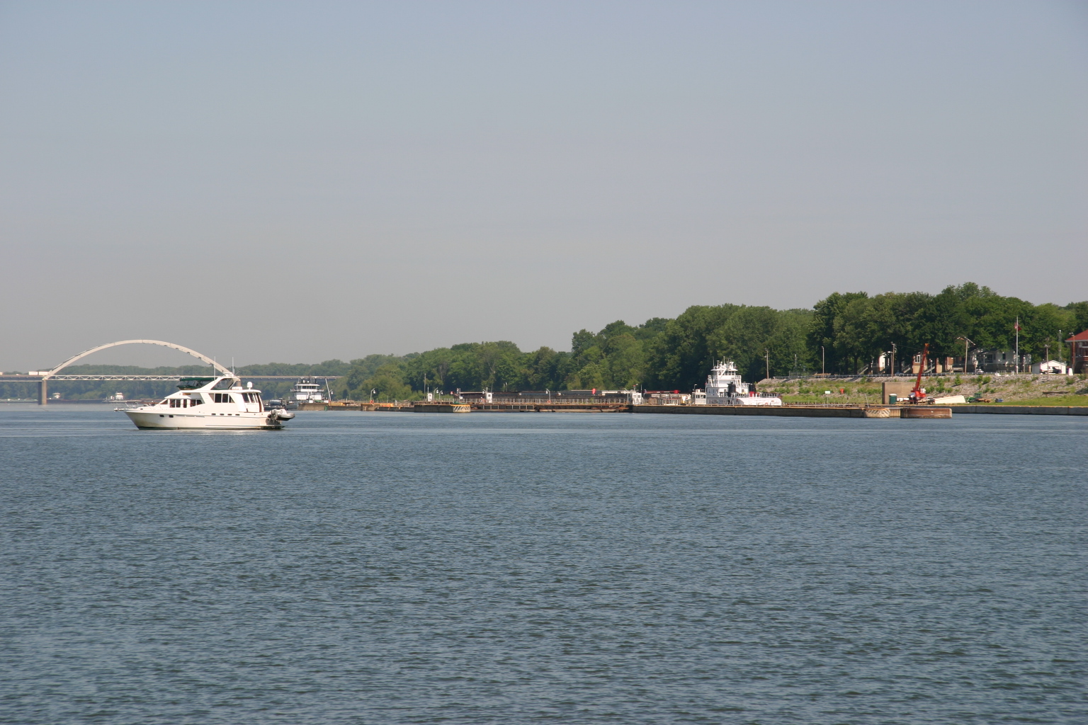


 second, larger Marlow showed up. We had seen Tru Blew just a few
days ago, when she stopped at Pebble Isle on her way north. With
Never Borred tied up in front on us and Tru Blew behind us,
we were a Marlow sandwich filling.
second, larger Marlow showed up. We had seen Tru Blew just a few
days ago, when she stopped at Pebble Isle on her way north. With
Never Borred tied up in front on us and Tru Blew behind us,
we were a Marlow sandwich filling. When
we arrived at
When
we arrived at  You
couldn’t have ordered better weather for a long cruising day. It was
cool and overcast all day, never raining, no wind. Perfect. We left
Keokuk ahead of our Twinkie, Jessica Marie, but she caught and
passed us before 8 a.m. When we reached
You
couldn’t have ordered better weather for a long cruising day. It was
cool and overcast all day, never raining, no wind. Perfect. We left
Keokuk ahead of our Twinkie, Jessica Marie, but she caught and
passed us before 8 a.m. When we reached 

 We
left the doggies to guard our air-conditioned boat, and Jon drove us to
the historic town of
We
left the doggies to guard our air-conditioned boat, and Jon drove us to
the historic town of  The
imposing workboat accompanying the dredge reminded us a lot of the
historic William M. Black we toured in Dubuque, but with a
jazzier, brighter paint job. This is a pleasant, small marina whose new
owners are maintaining true boaters’ hours during the summer season:
Open seven days a week, 8 a.m. to 8 p.m. Dockage was $1.00/foot.
The
imposing workboat accompanying the dredge reminded us a lot of the
historic William M. Black we toured in Dubuque, but with a
jazzier, brighter paint job. This is a pleasant, small marina whose new
owners are maintaining true boaters’ hours during the summer season:
Open seven days a week, 8 a.m. to 8 p.m. Dockage was $1.00/foot. We
went north as far as the Stillwater lift bridge, then turned around and
went back downstream 3 miles to
We
went north as far as the Stillwater lift bridge, then turned around and
went back downstream 3 miles to

 We
are staying at
We
are staying at
 It was fun to look around the John Deere Store, where you can find the
John Deere logos on an amazing variety of merchandise.
It was fun to look around the John Deere Store, where you can find the
John Deere logos on an amazing variety of merchandise.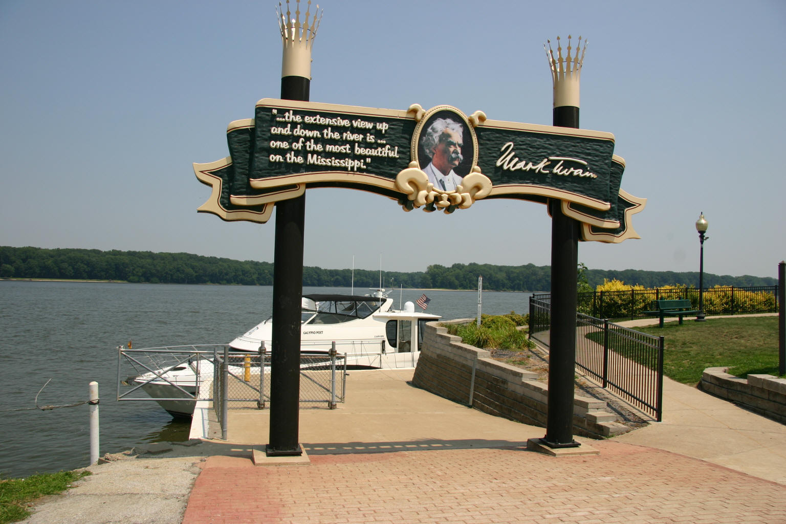 Three
locks today, and we’re finding a pattern: No wait for the first one,
short wait for the second, long wait for the third. We arrived in
Three
locks today, and we’re finding a pattern: No wait for the first one,
short wait for the second, long wait for the third. We arrived in
 details about the life of Samuel Clemens. The museum also has the
fifteen paintings Norman Rockwell created for his
details about the life of Samuel Clemens. The museum also has the
fifteen paintings Norman Rockwell created for his
 We
stayed at
We
stayed at
 The
weather forecast for this week is an interesting one. No rain at all in
the forecast, just high pressure and winds from the south, with the
temperatures on the rise. On really windy days, like today, a south wind
peels back the surface of the river, creating white caps and a bumpy
ride. And because the river is low, the wind attacks the surface of the
exposed sandbars, whirling clouds of grit into the air. Both of these
conditions are wearying to boaters trying to cover a lot of miles in a
day.
The
weather forecast for this week is an interesting one. No rain at all in
the forecast, just high pressure and winds from the south, with the
temperatures on the rise. On really windy days, like today, a south wind
peels back the surface of the river, creating white caps and a bumpy
ride. And because the river is low, the wind attacks the surface of the
exposed sandbars, whirling clouds of grit into the air. Both of these
conditions are wearying to boaters trying to cover a lot of miles in a
day.
