
July 26, 2002 / Mobile, AL to Alabama River Cut-Off Anchorage, Tombigbee River, AL
It's time to leave the coast and head inland. We
 will
spend the next several weeks on the Tombigbee, Tennessee, and Cumberland Rivers,
avoiding the Gulf during hurricane season. We have enjoyed our stay in Mobile,
but we are ready to return to the rivers.
will
spend the next several weeks on the Tombigbee, Tennessee, and Cumberland Rivers,
avoiding the Gulf during hurricane season. We have enjoyed our stay in Mobile,
but we are ready to return to the rivers.
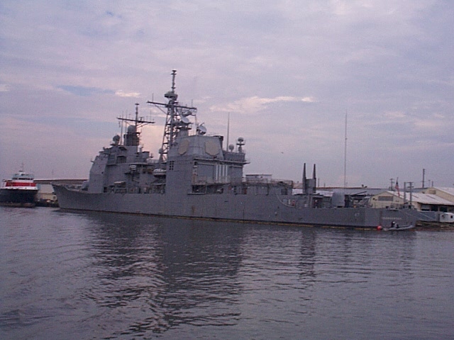
We departed Dog River at 0715, threading our way carefully back out the channel into Mobile Bay. Lots of shrimpers were working the Ship Channel this morning, and we followed a big ship into Mobile Harbor. This harbor is pretty cosmopolitan, ship-wise, as we saw vessels from Greece, Russia, Monrovia, Singapore, and the Middle East, plus a large Navy vessel, rigged big-time with satellite dishes and radar, the USS Ticonderoga.
Our route took us through Mobile Harbor and into what's officially called the Lower Black Warrior-Tombigbee Waterway. More accurately, however, we traveled north on the Mobile River until we reached the mouth of the Alabama River; at that point, we entered the Tombigbee River. The sailboat which had been docked to our stern at Grand Mariner Marina left about half an hour earlier than we did, headed up to Pickwick Lake, which is also our destination. We expect we'll see Trade Wind several times over the next few days.
The rivers were quiet, and the day was overcast, with occasional showers, and later in the afternoon, some lightning and thunder. We waited for an opening at one low bridge, at waterway mile 13.3 (call it the "14-mile Railway Bridge" and use Channel 13). The sailboat ahead of us just called it "Mobile River Bridge," and was corrected by the bridge tender. Two trains passed before the bridge opened, but our wait was quite short, just fifteen minutes.
Very little commercial or other traffic--one tow and a few bass boats and pleasure craft. Despite the cloudy conditions, we were steamy hot, then found out we were downstream from a coal-fired utility plant for producing electricity. The water temperature just below Barry Steam Plant was 104 degrees--it was like cruising in a hot tub.

At 1610, we anchored in the Alabama River Cut-Off on the Tombigbee River (waterway mile 52.8), a spot recommended in Fred Myers's very helpful Tenn-Tom Nitty Gritty Cruise Guide (4th ed. 2001). A thunderstorm threatened us to the west but did not strike. Shortly after we set anchor (bow and stern, as the channel is narrow), the sailboat Trade Wind pulled in behind us; they had attempted another anchorage (Bates Lake) a couple of miles upstream, but it was too shallow for their 5-foot draft. In contrast, the Alabama Cut-Off was about 16 feet deep at mid-channel, 11-12 feet deep closer to the south bank. We welcomed sailors Leo and Floyd to our anchorage, and we chatted a while on the radio with them. It was a quiet night--no waves and only a mild current (the Cut-Off flows into the Tombigbee).
Today's distance covered was 68.0 miles, run mostly at 1900 rpm.
July 27, 2002 / Alabama River Cut-Off, Tombigbee River, AL, to Bobby's Fish Camp, Silas (Bladon Springs), AL
We left our anchorage this morning at 0615; the sailboat was already gone. Mists were rising from the river surface, and once we got the dew cleared off the vinyl curtains, we could see glassy-smooth waters and quiet woodlands on either bank. The Tombigbee is not very wide for a navigable river with commercial traffic, so we were glad not to encounter many tows--only two the whole day, in fact.
We ran at varying speeds, between 1400-2000 rpm, slowing for docks and for fishermen, but there weren't a lot of the latter once the initial morning burst of bass boats passed us heading upstream. We don't know where all those boats went, as we didn't see them again--probably into the many bayous and creeks that feed into the Tombigbee.
At waterway mile 89.8 there is a lift bridge for the Southern Railroad. The bridge tender refers to it as the "Jackson Bridge." Luckily, we could see that it was open as it came into view. We called on Channel 13 to confirm that it would stay open, which it did. We caught up to Trade Wind just past the bridge, and as we were traveling close to the same speed, decided to stay together so we could transit the Coffeeville Lock together later in the day.
We had intermittent rain showers all afternoon, making things kind of steamy up at the helm. By watching Trade Wind ahead of us, we could tell whether we were heading into a clear spot or another shower. We reached the lock at 1600 hours, and the lockmaster had it open and waiting for us. Just a short way upstream from the lock is the only fuel stop (both gas and diesel) on this part of the river, Bobby's Fish Camp (telephone (251) 754-9225--note that the area code for southwest Alabama has changed from 334 to 251).
The guide books don't yet indicate that Bobby's has recently added a 100-foot floating dock to the small fuel dock (about 5 feet depth at dockside, dock runs parallel to shore), so there is more room for tying up overnight than there used to be. There's good catfish and coleslaw at the fish camp restaurant. Try the fried dill pickles. Gas was $1.80/gallon; the charge for dockage is $.50/foot, but there's no electricity or water. They will take a credit card, but only Visa (another change from guide book info).
Maggie rates Bobby's Fish Camp with two
![]()
![]() squirrels.
Folks here are friendly, but she got a little concerned when Coleen was warned
not to let her go swimming. They told us there used to be snakes around the
dock, but not any more--the alligators ate them.
squirrels.
Folks here are friendly, but she got a little concerned when Coleen was warned
not to let her go swimming. They told us there used to be snakes around the
dock, but not any more--the alligators ate them.
The fish camp's proprietor is named Bobby Dahlberg, and as Coleen's mother was born a Dahlberg, Coleen of course mentioned that fact. Turns out that Bobby's ancestors came from Sweden in early 1890s to this part of Alabama, where they learned English, worked at what jobs they could find, and wrote letters home to Mama in Sweden. Bobby's daughter Lora Jane has copies of letters written by Nils Dahlberg to his mother, describing life in Bladon Springs in 1891-1892, including the mob lynching of a murderous anarchist moonshiner who really riled his neighbors. In describing these events to his mother, Nils observed that Alabama was a lot different than Sweden, where prisoners at least went to court before they were hanged. He told her that as hangings were common, he expected he would see more of them.
Today's run was 68.2 miles, and we passed the cumulative 1000-mile mark for the trip.
July 28, 2002 / Bobby's Fish Camp, Silas (Bladon Springs), AL to Demopolis, AL
Another early morning start (0628), as we're learning that early morning in the summertime is the best time for river cruising. Temperatures are cooler, and the water surface peacefully and beautifully mirrors the trees on the banks and the clouds in the sky. On a winding river like the Tombigbee, it's fun to speculate what's around the next bend; you just hope it's not a tow pushing half a dozen barges. And usually, it's not. Still, today we saw a lot more towboat traffic than we've previously encountered on this waterway--six headed south and one headed north. We passed the northbound tow a little after noon, and we increased our speed so we could be well ahead of that tow when we reached Demopolis Lock late in the afternoon. We passed Trade Wind, too, but knew we'd see each other again at the Demopolis Yacht Basin, where we both planned to overnight.
This section of the river has many sand bars, attracting a number of weekend campers. We slowed for beached boats, for docked boats, and as always, for fishing boats. We even slowed for some guys on jet skis, but they were sorely disappointed; they wanted to jump our big wakes. We're nice guys; we obliged. They buzzed around us for ten minutes, then probably went to see their orthodontists to get their teeth retightened.
We arrived at Demopolis Lock at 1608, waiting about twenty
minutes to enter the lock. If there were other northbound pleasure boats today,
they may have had to wait several hours here for all the southbound tows to lock down.
We were lucky that we encountered those tows after they had transited
that lock. We also discovered that the
lockmasters and bridge tenders on this river evidently talk to each other, as
Demopolis knew we had been traveling with another boat the day before. When we
radioed this lock, the lockmaster asked whether we were traveling with another
vessel or whether we had gone on ahead, and after receiving our answer and the
information that Trade Wind didn't plan to arrive at the lock until 1800
hours, he decided to let us lock up alone.
Demopolis Yacht Basin has a curiously designed fuel dock that services tugboats on one side, pleasure boats on the other. Huge metal pylons anchor the dock and serve as a highly conspicuous landmark. We replenished our fuel tanks and headed for what we thought was our assigned slip. There was a strong westerly breeze, and the water was pretty shallow, yet Coleen backed the Poet into the slip with no mishap. Once we were secure (thanks for the help, John!), we found out we were in the wrong place. We would have stayed put, but after being warned that if the river's water level dropped (it's a foot above normal pool), we'd be marooned in a mudhole, we moved the boat around the corner to our original (and deeper) assigned spot.
Today's long run (97.5 miles) and sometimes fast speeds
(3900 rpm for about 40 minutes when we outran the tow and sailboat) drained our
gas tanks a little deeper, but gas at Demopolis is less expensive ($1.69) than
at our last stop, so we filled up. The marina has a laundromat (more dryers than
washers--smart), showers, and a satisfactory restaurant (closed Sunday, but open
Monday, despite what the cruise guide said). The marina charges $.75/foot for
dockage, electricity, and water, and there's a mostly functional courtesy van for driving into
town for supplies or sightseeing (rental bikes also available). Docks are floating, not fixed, so Maggie had
easy access to the pier from the swim platform. For that reason, plus the charms
of the riverside RV park adjacent to the marina which has big trees and squirrel
signs, she gives Demopolis Yacht Basin (telephone (334) 289-4374 (office); (334)
289-4647 (fuel dock)) a three-squirrel
![]()
![]()
![]() rating.
We'll stay here two days before proceeding upriver.
rating.
We'll stay here two days before proceeding upriver.
July 29-31, 2002 / Demopolis, AL
For those who have been trying to reach us by telephone or e-mail, sorry! We have not had a phone signal on much of the river, and even here at the marina, we get only a faint one. If you stand on the bridge with the phone facing southeast, close your left eye, and cross your legs at the ankles, you will get a signal that lasts just long enough for dialing the number; then it will disconnect. We're using a phone line in the manager's office to upload this segment of Leg Three.
We've been in Demopolis a little longer than planned. As we cranked up the generator on July 30, it got cranky and burned up something significant. So we've been waiting for an authorized serviceman to repair it (under warranty), and he arrived mid-morning July 31. At this writing, we don't know whether we'll be able to leave today or tomorrow, but we're comfortable at the marina, so we're content to stay if necessary.
Part of that contentment to stay is rooted in the rainy weather that just won't go away. We don't think we've had a day without rain since we arrived in Alabama. Since Maggie is part Labrador Retriever, she's accustomed to having webbed toes, but for Gary and Coleen, the evolution into water creatures is taking a little more time.
July 31, 2002 / Demopolis, AL to Sumter Landing, AL
The generator is running again (replaced circuit board for
voltage regulator), so we were able to leave Demopolis at 1040. The river banks
at Demopolis, and a little upriver, at Epes, are dramatic cliffs of white chalk.
 The skies stayed clear until late afternoon. We
reached Heflin Lock right behind two tows, and then it started raining, with a
little lightning and thunder thrown in. Maybe that's why the lockmaster felt
sorry for us and let us lock through with the second tow (it was pushing only
one barge, so there was plenty of room for us both).
The skies stayed clear until late afternoon. We
reached Heflin Lock right behind two tows, and then it started raining, with a
little lightning and thunder thrown in. Maybe that's why the lockmaster felt
sorry for us and let us lock through with the second tow (it was pushing only
one barge, so there was plenty of room for us both).
Just a few miles upstream from the lock is a nice anchorage, at Sumter Landing (waterway mile 270). Our only concern is that the entrance seems to be silting in, as our depth finder showed a bar across it registering 3.9 and 4.1 feet--and we draw 3.5 feet. We put the engines in neutral and let momentum carry us across. Inside, the depth was 11-12 feet. There's a boat ramp and a little campground. Plenty of room to swing on one anchor.
No people were there, but we saw two dogs roaming the campground, no collars. One was a black Lab mix, with an injured front paw. She was very interested in Maggie, although shy. She finally got brave enough to sniff noses and then followed us on the rest of Maggie's walk. As we got into the dinghy to row back to the Poet, she swam after us. Seeing that we weren't going to let her board, she gave up and returned to shore, where we saw her and her buddy again the next morning as we were departing. We hope they live at some farmhouse nearby and haven't been abandoned there.
Today's run was 53.9 miles, run mostly at 1950 rpm.
August 1, 2002 / Sumter Landing, AL to Marina Cove, Carrollton, AL
Today's run was a short one (about 37 miles), so we took it easy in the morning, not departing Sumter Landing until 0817 and not exceeding 1950 rpm. Only one tow today, southbound, so we had no delays at the lock. There is a fairly extensive dredging operation going on just below Tom Bevill Lock. We radioed for instructions, and were told to "stay in the river and keep the dredge to starboard." We thought staying in the river sounded like a good idea!
 Built above the Tom Bevill Lock is a beautiful building,
constructed in the late 1980s but modeled on three historic homes from the area.
This building serves as the Visitor Center for this section of the Tenn-Tom, but
they don't have many visitors, which is a shame. We climbed the stairs to the
belvedere, where we had great views of the lock, the river, and an early
20th-century snagboat, the Montgomery, which is normally open for tours,
but since we were coming, was "closed for relocation," even though, as far as we
can tell, it doesn't even have a restaurant.
Built above the Tom Bevill Lock is a beautiful building,
constructed in the late 1980s but modeled on three historic homes from the area.
This building serves as the Visitor Center for this section of the Tenn-Tom, but
they don't have many visitors, which is a shame. We climbed the stairs to the
belvedere, where we had great views of the lock, the river, and an early
20th-century snagboat, the Montgomery, which is normally open for tours,
but since we were coming, was "closed for relocation," even though, as far as we
can tell, it doesn't even have a restaurant.
We are pleased to recommend Marina Cove (telephone (205) 373-6701) to boaters transiting this part of the Tombigbee. It's set back from the river, which means the water is fully protected from wakes and waves. There's a fuel dock (selling both gas and diesel) on the northeast bank around behind the boat slips. You can borrow a courtesy vehicle to drive to the Visitor Center (and listen to the dockmaster's bagpipe music on the vehicle's cassette tape recorder--reminding Coleen of last summer's trip to Scotland). We were assigned to a slip on the nice floating dock, and later in the afternoon, watched from our aft deck as another Carver came in for the night. We enjoyed a mini Carver rendezvous with Tom and Maria aboard Oasis. They're returning home to Woodstock, GA, after spending the summer at Panama City, FL, and they shared several good tips with us for marinas and restaurants on the Gulf Coast and on the Tennessee River.
Maggie finally got to voluntarily swim (twice!), and she
enjoyed lounging on the dock while Mom and Dad visited with the people in the
boat in the next slip. No real squirrels in evidence around this marina, but
that's really the only drawback, from a doggy point of view. She'll give Marina
Cove a
![]()
![]() rating.
rating.
August 2, 2002 / Marina Cove, Carrollton, AL to Columbus, MS
We left Marina Cove at 0748, just as a tow was coming out
of the Tom Bevill Lock. Coleen radioed the tow to ask if we could "scoot ahead,"
since we didn't want to be stuck behind him all the way to Columbus. The towboat
captain said okay, so we scooted. Not being familiar with what was ahead,
however, we didn't know we'd be continually slowing to no-wake speed for all the
boats and docks in the most populous riverside area we've
seen so far on the Tombigbee (river miles 309-315). We kept checking our rear to be sure the tow
wasn't bearing down on us from behind.
 We managed, finally, to pull away from
the tow, and by 1132 were secure in our only lock of the day, Stennis Lock. By
1215 we were tied up on the transient dock at Columbus Marina.
We managed, finally, to pull away from
the tow, and by 1132 were secure in our only lock of the day, Stennis Lock. By
1215 we were tied up on the transient dock at Columbus Marina.
Columbus Marina (telephone (662) 327-8450) caters to
powerboaters; the only sailboats we saw were in drydock. The marina owners,
Chuck and Barbara Bigelow, spent many years as charter and delivery captains, so
they know exactly what they like and dislike about marina facilities. When
they built Columbus Marina a couple of years ago, they put in what they liked
best. The result is a first-class operation, all the way around (e.g.,
ultra-modern floating docks with all connections, an air-conditioned
laundry room whose machines needed no quarters--just tell Barbara how many loads
you did and she'll add it to your bill). Dockage rate was $.75/foot. Our only
disappointment was (surprise) that the restaurant adjacent to the marina was
closed, though it's due to reopen under new owners in the winter. Maggie enjoyed
the marina as much as we did. While she didn't find any squirrels, there were a
bunch of Canada geese to chase and a good swimming spot from the small boat
launch ramp. She hung out in front of the ship's store door and acted like she
was the marina dog. Four squirrels
![]()
![]()
![]()
![]() for
Columbus Marina!
for
Columbus Marina!
We met Larry and Carroll Adams from Birmingham, AL, who had found our web site on the BoaterEd bulletin board, and who e-mailed us to arrange a rendezvous. Their boat, Never Say Never, had been at Demopolis Yacht Basin and they had just missed us when we were there. As it turned out, they were moving the boat to Columbus for a couple of months. Their one-day cruise on Friday up from Demopolis was accomplished in such hot weather that Carroll was keeping ice in her pockets to cool down. We had a very nice dinner with them Saturday night at Harvey's Restaurant in downtown Columbus (thanks again). Another friend from Demopolis was also at Columbus Saturday night, our friendly "dockhand" John, whose lovely mom Charlotte was with him. Not that Gary and I have run out of things to talk to each other about, but it was still nice to have other intelligent and interesting people to spend time with.
August 4, 2002 / Columbus, MS to Smithville, MS
The river was very quiet today. We saw no tows at all, just a fair number of Sunday fishermen. We had originally planned to stop at Aberdeen, Mississippi, but the prospect of going through a couple more locks with no tows around us and, therefore, no waiting, was too enticing to pass up. After you pass Aberdeen, you leave the Tombigbee River and enter a canal, but it's very wooded on both sides and doesn't make you feel claustrophobic.
We reached Smithville Marina at 1426, where we were met by
its owner, Jesse Cox, a Southern gentleman whose grandfather bought the land the
marina's on (and which some of the canal is over) in 1886. We asked Jesse to
recommend a restaurant, and he sent us in the marina courtesy car to Pete
Atkinson's Steakhouse (which also specializes in catfish). The restaurant specially
reserved a table for us and put up some decorations for Coleen's upcoming birthday,
even offering
a slice of birthday cake on the house. Smithville Marina is very modest but
welcoming, and Maggie enjoyed hunting squirrels among the trees and taking a
cooling dip in the water from the launch ramp. Jesse helped with the squirrel
offensive by putting a cob of corn into a squirrel feeder by the marina office.
Maggie rates this place two juicy squirrels
![]()
![]() .
.
Today's run was 42.7 miles, with rpms ranging from 1100 to 2000, depending on our mood and the number of fishing boats around us at any given time.
August 5, 2002 / Smithville, MS to Pickwick Lake, MS
The Tenn-Tom has twelve locks that must be transited in
going north to Pickwick Lake, many of them only a few miles apart. We were
fortunate in encountering only one wait on the entire Tenn-Tom, and even then,
we were able to lock through with the small tow in front of us. The lockmasters
have all been polite and friendly. Today was particularly nice, because as we
approached Fulton (mile 391.0), Rankin
(mile 398.4), Montgomery (mile 406.7), and Whitten (mile 411.9) Locks, they were
each open and waiting for us.
 We had read about huge Whitten Lock,
which raises boats 84 feet, but once we were in it, it didn't look that much
more imposing than the Dardanelle Lock on the Arkansas River.
We had read about huge Whitten Lock,
which raises boats 84 feet, but once we were in it, it didn't look that much
more imposing than the Dardanelle Lock on the Arkansas River.
Three of the locks will be closing for regular maintenance soon, so there's little commercial or other traffic; the tows we saw today were all southbound. Get caught between these locks during closure, and you'll be spending a lot of time at your present marina or anchorage until they re-open. Fortunately, the closures are well publicized in the Local Notices to Mariners, and the marinas are also good about spreading the word.
We also want to pass on information about a mystery marina at mile 403. It's very small but sells both gas and diesel, as well as crickets, minnows, and other bait. While it's shown on the Tenn-Tom river chart (circa 1991), Fred Myers makes no mention of it in the 2001 edition of the Nitty Gritty Tenn-Tom Cruise Guide. We found it, however, in the Deliverycaptains.com cruise guide for the Great Circle Route: Murphrees Waterfront Camping, telephone (662) 585-3058. If you needed fuel or an emergency place to stay, this might be your only option on this part of the river.
Our planned itinerary had us anchoring overnight in Bay Springs Lake, but try as we might, we couldn't get either of our anchors to hold on the slick clay bottom. We gave up and opted to keep going north to Pickwick Lake, where we arrived at Aqua Yacht Harbor at 1915. As we proceeded through the Divide Cut, the canal connecting the Tombigbee and Tennessee Rivers, we kept encountering groups of water skiers (including a barefooter), who saw no reason not to drop, stop, and change skiers in the middle of the narrow channel, even as we approached.
Today's run was 75.5 miles, run at rpms ranging from 1100 to 2600, with the most hours run at 1400 rpm. We were on the water for twelve hours, but that's also counting the time we wasted trying to anchor on Bay Springs Lake.
August 6-12 / Pickwick Lake, MS/AL/TN
As
we conclude Leg Three, our total cruising distance has reached 1339 statute miles. We'll stay at
Aqua Yacht Harbor, on the Mississippi side of Pickwick Lake
for a week, then begin Leg Four northward on the Tennessee River.
Aqua is a big facility, with about 600 slips, a yacht broker, on-site restaurant (open!), pool, laundry, showers, multiple courtesy vans, and plenty of space for transients. The transient dock is on the outside of the farthest-out pier (also where you'll find the fuel dock). While this is handy for tying up, it also means that you'll catch a lot of wakes from whatever vessels or PWCs are passing by in the lake. It also means that you are a pretty long walk from the laundry (with all these slips, why just one washer and one dryer?), showers, pool, restaurant, and all those other nice accoutrements. Folks are friendly and helpful, though. They helped us find a canvas shop, as we've decided we need more ventilation on the front of the bridge. In addition, Gary found a boat electronics technician working on another yacht who can get us the software upgrade we need for our Furuno electronics (to stop the drift alarm from going off when we're not drifting).
Several additional restaurants are nearby, but far enough away you'll want to drive one of the courtesy vans. Being on the water surrounded by hills means we couldn't get a cell phone signal, but the fuel dock office let us use a phone line for e-mail and web site updating.
As nice as Aqua is for people, it's not so great for dogs:
a long uphill hike to the designated doggie "exercise" area, nowhere to swim,
and no squirrel trees. We haven't even seen other dogs to sniff noses
with. For these reasons, Maggie rates Aqua only 1 squirrel
![]() in the dogworthiness
ratings.
in the dogworthiness
ratings.
Click to go to Leg 4.
![]()